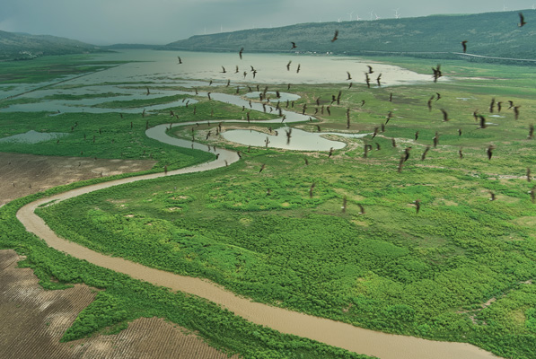
Water Replenishment Projects
ThaiBev recognizes that water challenges vary across locations, which means that water management
must be carried out in accordance with local contexts.
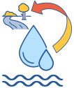
The company prioritizes infrastructure improvements
for water replenishment projects and enhances water resource security by using the Volumetric Water Benefit Accounting (VWBA) methodology to measure and
monitor the effectiveness of operations to ensure that ThaiBev’s water management has a sustainable positive impact on communities and the environment.
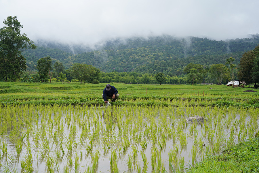
Community Water Management Project in accordance with the Royal Initiative of Muang Mae Haad Community, Thailand
ThaiBev, in collaboration with the Hydro-Informatics Institute (Public Organization) (HII), implemented the
Mae Haad Weir Rehabilitation Project to improve the local water system in the Muang Mae Haad community.
The project covers three villages—Ban Mae Hoy,
Ban Muang Klang, and Ban Ku Ho—in Ban Luang
Sub-district, Chom Thong District, Chiang Mai Province,
and aims to address water scarcity for both agricultural
and household use, particularly during the dry season.
In 2025, the project successfully increased the water delivery efficiency for agriculture areas from 10 rai per day to 15 rai per day—a 50 percent increase. This increase enables dry-season cultivation across 652 rai, nearly matching the 775 rai cultivated during the rainy season.
The project also provided household water supply to
139 households, totalling approximately 22,500 cubic meters per year, or an average of 162 cubic meters
per household per year. In total, the initiative delivered 49,750 cubic meters of water annually, supporting both agricultural production and daily consumption needs.
This outcome demonstrates the project’s success
in strengthening water security and resilience for the Muang Mae Haad community. By improving access
to reliable water resources, the initiative supports
sustainable agriculture, enhances community livelihoods, and contributes to long-term water sustainability.
Water Conservation at Bung Jagoi Heritage Village, Malaysia
F&NHB’s Borneo Springs mineral water, which is sourced from a 130-million-year-old rainforest, partnered with
the Jagoi Heritage Association (JHA), through its Jagoi Area Development Committee (JADC), to provide a sustainable water supply to Bung Jagoi Heritage Village in Kuching, Sarawak, Malaysia. The initiative, which focuses on
water conservation and forest rehabilitation, including
the installation of a new water pump system drawing clean water from Ayak Tibodak and the repair of water storage tanks, is expected to replenish up to 5.475 million liters
of water annually. This initiative strengthens long-term water security for the village while supporting eco-tourism and the preservation of its cultural heritage.
Area-Based Development Project in Chiang Dao,
Thailand
ThaiBev, in collaboration with the Mae Fah Luang
Foundation under Royal Patronage, implemented an area-based development initiative in Chiang Dao District, Chiang Mai Province. The initiative focused on the Khilek Weir Rehabilitation Project in Ban Chomkiri, Mae Na Sub-district, which aims to develop efficient local water systems and replenish water to nature and surrounding communities. The project has adopted the Sufficiency Economy Philosophy (SEP) in Action and a community participatory approach. Local residents were engaged throughout the process, beginning with the area survey, through problem identification, to solution development and the weir rehabilitation. Community members
played an important role in both contributing labor
and establishing a Community Water Fund to support the ongoing maintenance and development of the
water system. This participatory model has fostered
a strong sense of ownership among community
members and laid the foundation for long-term
water sustainability.
Following the rehabilitation, the Khilek Weir—serving
as an agricultural water source—now provides irrigation for 115 rai of farmland, benefiting 29 farming households.
The improved water access has enabled farmers to expand their cultivated crops from four to six types, including rainy-season rice, dry-season rice, sesame, longan, mango, and sweet corn, thereby contributing
to increased agricultural productivity. As a result, the community’s total annual income increased by more than 47 percent, from 556,363 Baht to 816,163 Baht. In addition, the project successfully replenished 19,643.5 cubic meters of water to nature and the community, calculated in accordance with the VWBA international standard, based on crop water requirements per rai.
Beyond economic and environmental outcomes,
the project also created social value by strengthening
community capacity in water governance. Through
the Community Water Fund, local members jointly plan, maintain, allocate, and manage water resources with transparency and accountability, enhancing their
preparedness for future water-related risks.
The Khilek Weir Rehabilitation Project exemplifies
effective collaboration between the private sector
and local communities. It demonstrates ThaiBev’s continuous efforts to advance sustainable water management, support community resilience,
and contribute to the United Nations Sustainable
Development Goal (SDG) 6: Clean Water and Sanitation.